
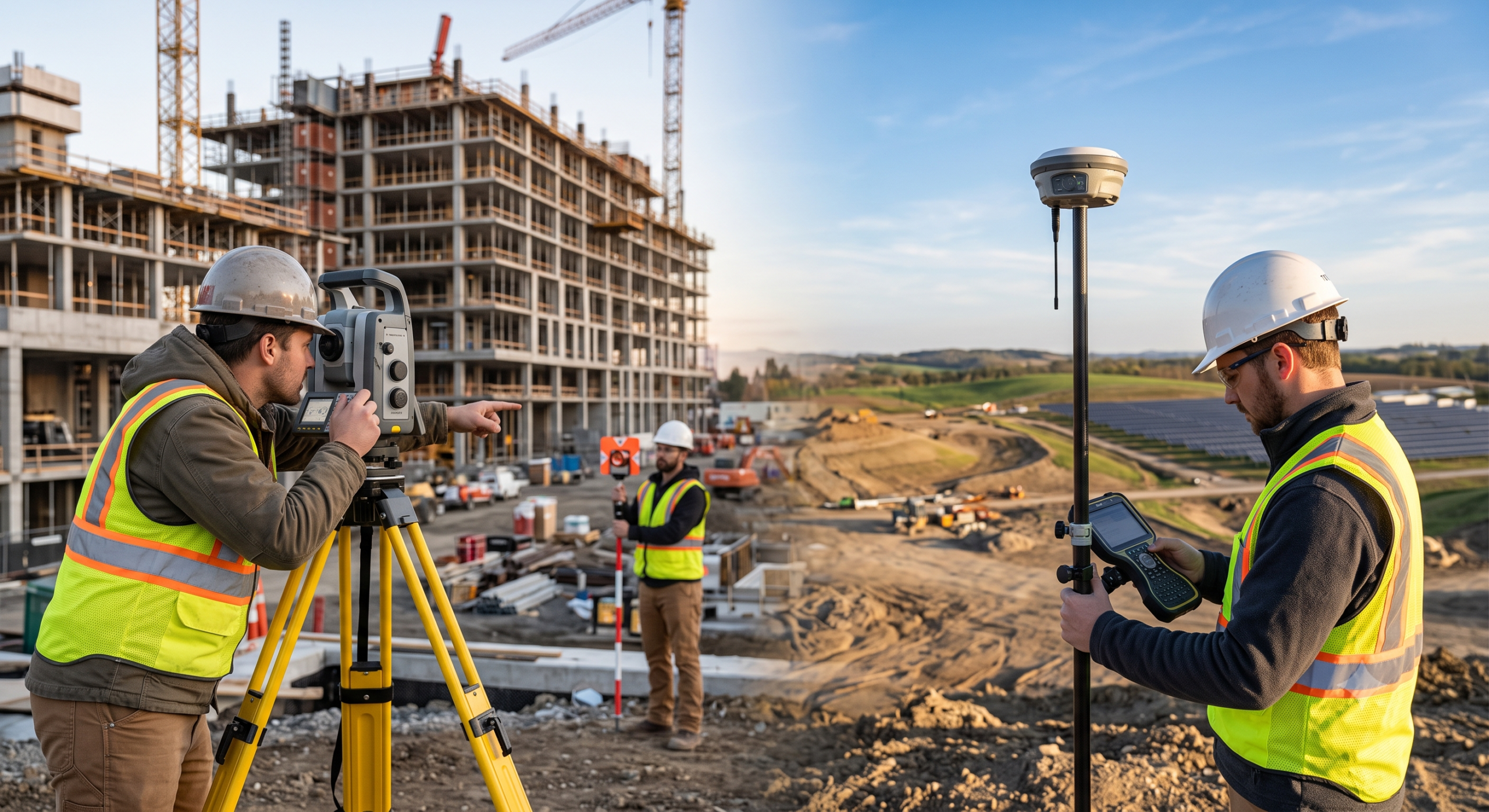
These two instruments answer the same question — where exactly is this point? — using completely different physics, and that difference is what determines which one belongs in your hands for a given task. A total station measures angles and distances relative to a known point using line of sight. A GNSS receiver calculates its own position from satellite signals, with no need to see any reference instrument at all. Everything else — accuracy characteristics, environmental limitations, workflow speed — follows from that one core distinction.
How a Total Station Actually Works
A total station combines two older instruments into one: a theodolite, which measures horizontal and vertical angles precisely, and an Electronic Distance Measurement (EDM) unit, which measures distance by timing a reflected signal to a prism (or, on reflectorless models, directly off a surface). Set up over a point of known coordinates, sight a target, and the instrument calculates the target’s position from the measured angle and distance — straightforward trigonometry, executed with extreme angular and distance precision.
The one requirement this imposes that GNSS doesn’t share: the instrument must have direct line of sight to the target. No line of sight, no measurement — which is the source of both the total station’s biggest limitation and, in the right setting, its biggest advantage.
How a GNSS Receiver Actually Works
A GNSS receiver calculates its own position by measuring signals from satellites — GPS, GLONASS, Galileo, and BeiDou depending on the receiver — and, for survey-grade precision, applies correction data through RTK or PPK positioning (covered in detail in our RTK explainer). Because it derives position from satellites overhead rather than from sighting another instrument, a GNSS rover has no line-of-sight requirement between points — the tradeoff is that it needs a reasonably open view of the sky instead, and its accuracy depends on satellite geometry and correction quality rather than on optical precision.
Side-by-Side Comparison
| Total Station | GNSS Receiver (RTK) | |
|---|---|---|
| Measurement principle | Angles + distance from a known point | Satellite trilateration + correction |
| Line of sight required | Yes, to every point measured | No, between points — but needs open sky |
| Typical horizontal accuracy | Millimeter-level | Centimeter-level |
| Typical vertical accuracy | Comparable to horizontal | Roughly 2–3× worse than horizontal |
| Works underground / indoors | Yes — the only real option | No — no satellite signal |
| Works under dense canopy | Yes | Degraded or unreliable |
| Setup speed on large open sites | Slower — requires instrument setup and line-of-sight planning per point cluster | Fast — a single rover can move across an open site quickly |
| Crew size (robotic models) | One person, with automatic prism tracking | One person |
| Best-suited environment | Tight tolerances, urban/built-up areas, tunnels, structures | Open sites, large-area topographic work, GIS data collection |
Where Each Instrument Actually Wins
GNSS wins on open sites, large-area topographic surveys, boundary work across acreage, and general GIS data collection, simply because a rover can move quickly across open ground without setting up sightlines between every pair of points. It’s also the practical choice for machine-control positioning on active earthmoving equipment, where a fixed sightline to a total station would constrain how the machine can move.
Total stations win wherever line-of-sight precision genuinely outperforms satellite-based positioning: building corners and structural steel layout, concrete formwork, anchor bolt placement, and any tight-tolerance construction layout where the accuracy difference between total-station millimeters and GNSS centimeters actually matters to the work. They’re also the only viable option in environments where GNSS simply doesn’t function — underground tunnels, mines, and structures with no sky view — where drift alignment, breakthrough calculations, and pit-wall mapping depend entirely on optical instruments.
One accuracy detail worth internalizing regardless of which instrument you’re using: GNSS vertical accuracy is consistently worse — roughly two to three times worse — than its horizontal accuracy. Design your survey and your tolerance expectations around that asymmetry rather than assuming a single accuracy number applies in both dimensions.
Robotic Total Stations Aren’t GNSS — Don’t Confuse the Two
A robotic total station automates prism tracking so a single surveyor can operate the instrument remotely instead of needing a second person to hold the target — a genuine productivity gain, letting one person do work that used to require two. But this is an automation improvement to the same angle-and-distance measurement principle, not a shift toward satellite positioning. A robotic total station still requires line of sight and is still bound by the same fundamental physics as a manual one.
Where this gets genuinely interesting is a newer category of hybrid positioning systems, where manufacturers mount a lightweight GNSS receiver directly on the prism pole. This doesn’t turn the total station into a GNSS instrument — it uses the GNSS position to speed up instrument setup and target reacquisition (for example, resectioning the instrument’s own position from GNSS readings, or helping the robotic total station reacquire a lost prism), while the actual point measurements still come from the total station’s angle-and-distance system. It’s a genuinely useful convenience layer, not a replacement for either core technology.
The Real-World Answer: Most Professional Crews Use Both
The practical answer to «which one should I buy» for most surveying and construction-layout operations isn’t either/or — it’s both, deployed where each performs best. A common real workflow: use RTK GNSS to collect topographic data, establish overall site control, and stake points across large open areas quickly, then switch to a robotic total station once work moves into zones with limited sky visibility or tighter accuracy requirements — building corners, structural steel, anchor bolts, or areas between completed structures where GNSS signal is partially blocked.
This hybrid approach has become close to standard practice on infrastructure and construction projects specifically because it maximizes speed on the open-site portion of the work while preserving millimeter-level precision exactly where the project actually demands it.
Who Should Prioritize Which Instrument First
- Land surveyor doing boundary and topographic work over large open acreage → GNSS RTK first; add a total station or robotic unit as budget allows for tighter-tolerance jobs.
- Construction layout crew working primarily on structures, formwork, and steel → Total station (ideally robotic) first — this is where line-of-sight precision earns its keep daily.
- Firm doing tunnel, mining, or underground infrastructure work → Total station is not optional here; GNSS simply doesn’t function in these environments.
- Growing firm building a full-service capability → Budget for both, and plan the workflow split (open-site GNSS, tight-tolerance total station) into your standard operating procedure rather than treating it as an edge case.
Final Verdict
A total station and a GNSS receiver aren’t competing versions of the same tool — they’re solving the positioning problem with different physics, which is exactly why the «which is better» framing misses the point. GNSS wins on speed and coverage across open terrain; total stations win on line-of-sight precision and function in environments where satellites simply can’t reach. The professional answer, borne out by how most surveying and construction crews actually operate today, is to own both and route each job to whichever instrument’s underlying physics actually fits the working conditions.
Want the deeper mechanics of how GNSS achieves its centimeter-level accuracy in the first place? Our guide to how RTK actually works covers the carrier-phase measurement and correction process behind every GNSS rover.